The most curious enclaves in the world
|
NEWS
Source: listas.20minutos.es
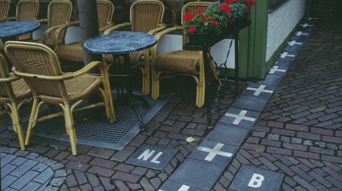
Territory of one state located within another. This is very curious, but there are territories within another territory, which only divide streets, houses, bedrooms, etc.
TOP 31:
The Fergana Valley
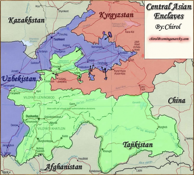
It is shared by Uzbekistan, Tajikistan and Kyrgzstan and is a virtual archipelago of enclaves that pose serious challenges to state sovereignty no. Kyrgyzstan: There is a small town in Kyrgyzstan, Barak, in the region of the Fergana Valley that is located in Kyrgyzstan, Tajikistan and Uzbekistan. The town is surrounded by Uzbek territory and about two square kilometers in size. Tajikistan: There are three Tajik enclaves, all of them in the Fergana Valley. One of them, the town of Sarvan, is surrounded by the territory of Uzbekistan, while the remaining two, the town of Vorukh and a small [unidentified?] Settlement near the Kairagach Kyrgyzstan train station, are each surrounded by Kyrgyz territory. Uzbekistan: There are four Uzbek enclaves, the entire territory of Kyrgyzstan in the interior, in the Fergana Valley. Two of them are the cities of Sokh and Shakhimardan and the other two the small territories of Chong-Kara and Dzhangail. There may be a fifth exclave Uzbekistan within Kyrgyzstan however I have only found a map that supports it (thanks to Nathan). However, the enclaves and exclaves in Fergana are on par with space science in terms of difficulty.
TOP 30:
Northwest Angle, Minnesota
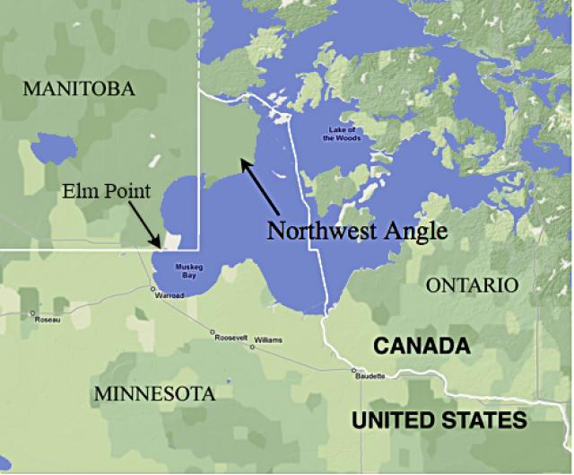
The Angle Inlet or Northwest Angle (in Spanish, 'Northwest Angle'), known simply as "The Angle" among the locals, is a small part of the US territory that, with the exception of Alaska and Point Robert, is the only one It is located further north of the 49º N parallel (parallel that marks the northern border with Canada, from the West Coast along the northern borders of the states of Washington, Idaho, Montana, North Dakota, and part of Minnesota). The Angle Inlet is located north of Lake Forest County, in Minnesota, and is inaccessible by land from the rest of the United States. It is accessed from Canadian territory or by sailing or flying over Lake of the Woods. With the exception of this area, the territory of the 48 contiguous states does not extend further north. Some projections of the American map sometimes create a superficial appearance, extending further north to Maine than to Angle Inlet, which is a mistake. The Northwest Angle.
TOP 29:
Kentucky curve
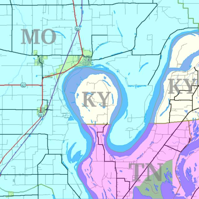
The Kentucky curve, variously called New Madrid Curve, Madrid Curve, Bessie Curve or Bubbleland, [1] officially known by the United States Census Bureau as the West Census County Division, is an exclave of Fulton County, Kentucky, in U.S . Kentucky Bend is a piece of land inside a meandering horseshoe loop of the Mississippi River. Surrounded by the states of Tennessee and Missouri, without touching any other part of Kentucky, it is an exclave of Kentucky. Kentucky Curve is the corner of the southwestern end of Kentucky. The peninsula includes the lowest point in the state of Kentucky, on the banks of the Mississippi River. The only road in the area is Tennessee State Route 22, whose continuation in Kentucky Curve was once signed as Kentucky State Route 313.
TOP 28:
Jungholz, Austria within Germany.
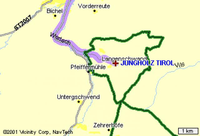
The summit at more than 1,600 meters of altitude of a mountain marks one of the few places in the world where the borders form a quadrifinuium, that is, a border cross. Jungholz and the rest of the country to which it belongs (Austria) only intersect at a single geometric point. That situation leaves the people as an intruder in Germany, a place that can only be accessed from Austria crossing overseas. One more, but one of the rarest.
TOP 27:
Karki, Barkhudarli and Yukhari Askipara (together with Asagi Əskipara)
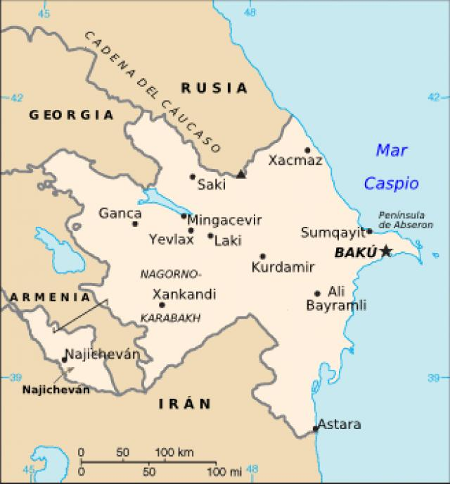
They are 3 small enclaves of Azerbaijan within the Armenian territory, take into account those small points of the Azeri territory, those are the enclaves.
TOP 26:
Nagorno-Karbagh
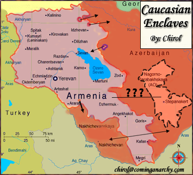
Currently occupied by Armenia and although ethnically Armenian, technically belongs to Azerbaijan. At the moment, it has declared itself to be an independent state, although it has been recognized by no one. If it were to eventually become a state, about seven new enclaves would exist within it.
TOP 25:
Point Roberts, Washington State
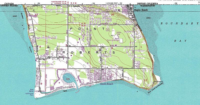
Point Roberts is an unincorporated area located in Whatcom County in the US state of Washington. Politically it is part of the United States although it is not physically connected. By land it can be accessed through Canadian territory, it can only be accessed directly by plane or ship.
TOP 24:
Gambia
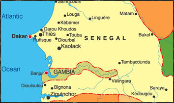
The Gambia, which is prevented from being an enclave in a small strip of ocean. Surrounded entirely by Senegal
TOP 23:
Artsvashen
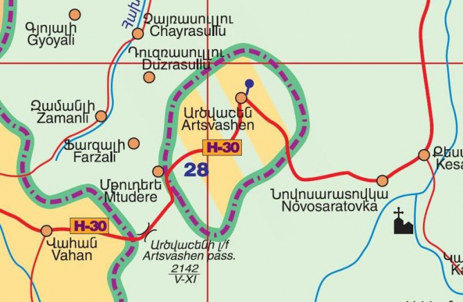
It is a small city founded in 1845, it is an exclave of the Armenian province of Gegharkunik totally surrounded by Azerbaijan, whose surface is around 40 km². It was an exclave of Armenia since 1931, when the Soviet Union ceded the territory that connected it directly with Armenia to Azerbaijan, within the framework of a series of border adjustments in the southern Caucasus. Currently, Azerbaijan controls the exclave since the Nagorno Karabakh war, specifically since August 1992, when the Armenian army evacuated 4,500 Armenians, after a series of armed meetings in which the Armenians suffered 44 casualties, 12 of them in a ambush of Azeri soldiers who would have pretended to be Armenians.
TOP 22:
Oecussi-Ambeno
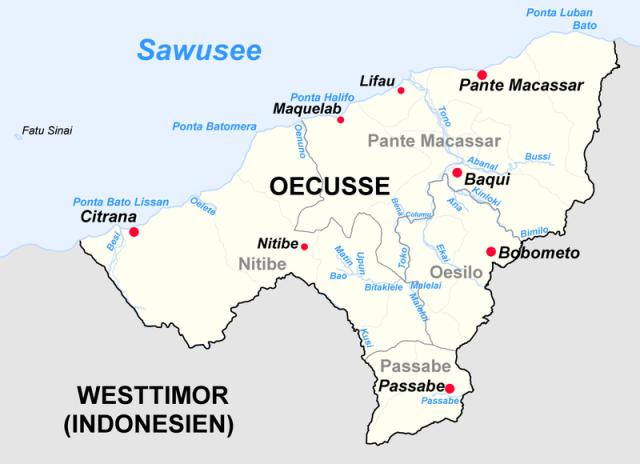
Oecussi-Ambeno (also Ocussi, Oekussi, Oekusi, Okusi, Oé-Cusse) is one of the districts of East Timor. It is a coastal exclave in the western part of Timor Island, separated from the rest of East Timor by West Timor, which is part of Indonesia. To the north of the exclave is the Savu Sea. The capital of the province is Pante Macassar, also called Pante Makassar or Ocussi Town. It was in Pante Macassar where the fifth column of the Indonesian army waved its country's flag and took control of the enclave on November 29, 1975, a week before the Indonesian invasion of the rest of East Timor. Still under Indonesian rule, Oecussi-Ambeno was administered as part of the province of East Timor (Timor Timur in Indonesian), as well as when it was administered by the Portuguese as part of Portuguese Timor. Consequently, it became part of the independent state of East Timor on May 20, 2002.
TOP 21:
The Autonomous Republic of Nakhichevan
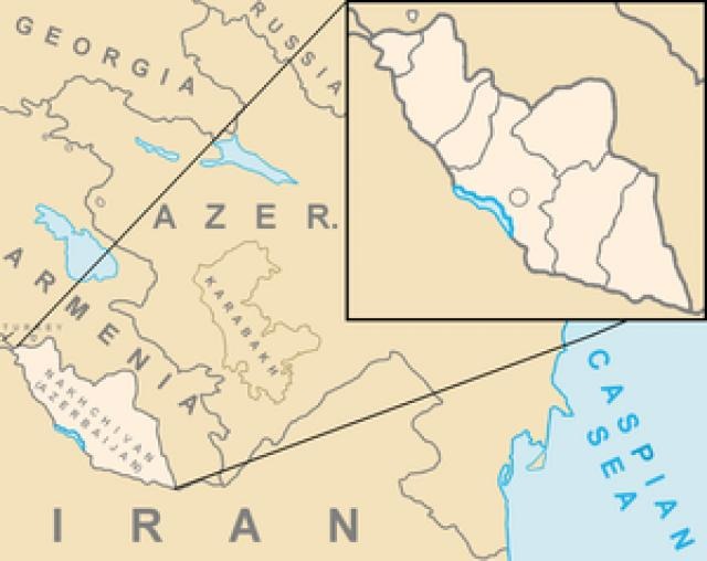
Nakhichevan is a semi-desert region of Azerbaijan separated from the rest of the country by Armenia. The Zangezur Mountains to the east make up its border border with Armenia, while the Aras River to the west defines its border with Iran.
TOP 20:
Cocobeach
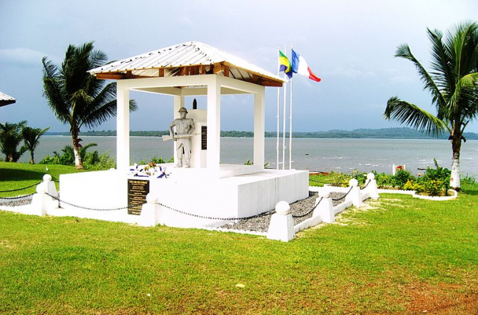
Cocobeach is a binational city of both Gabon and Equatorial Guinea. It is the capital of the Estuaire Province of the Department of Noya Gabon. It is located in the northwest of the province of Estuaire, Gabon; and in the southwest of the province of Litoral, in Río Muni, the continental part of Equatorial Guinea.
TOP 19:
Cabinda
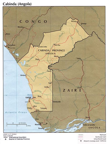
It is one of the 18 provinces in which Angola is administratively divided. It is an exclave of Angola to be separated from the rest of the country by the Democratic Republic of the Congo, which surrounds the province by the east and the south. To the north is the Republic of the Congo and to the west the Atlantic. In 2006 it had an estimated population of 264,584 inhabitants, with an area of 7,270 km². Certain groups have sought the independence of the exclave under the name of Republic of Cabinda, because they demand more attention to the province, rich in oil.
TOP 18:
Apipé Islands
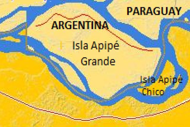
they are fluvial islands of Argentina located between the province of Corrientes (province to which they belong) and the department of Misiones, Paraguay. It is made up of two islands: Apipé Grande and Apipé Chico, which cover an area of 25,000 ha. Both are surrounded by arms of the Paraná River. The Yacyretá-Apipé Hydroelectric Dam, which began operations in 1994, and provides energy to the island, has made the islands practically covered with water from the reservoir. Apipé Grande has a population of about 2000 inhabitants; This island has a small town called San Antonio.1 While the sovereignty of the islands is Argentine, the waters that surround them belong to Paraguay, which transforms these lands into an enclave; This situation is generating innumerable conflicts, mainly in the inhabitants of the island when they want to be transported to the rest of the Argentine territory.
TOP 17:
Bosnia and Herzegovina
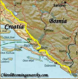
Bosnia has an exclave, Sastavci, located in Serbia and Montenegro. Below is a map of a part of Croatia, which includes the city of Dubrovnik, which is isolated from the rest of the country by Bosnia, which has a small strip of coastline. Since it has access to open water, it is not an enclave, although it is an enclave.
TOP 16:
Mahda and Nahwa, Oman within the Arab Emirates (and in turn within Oman).
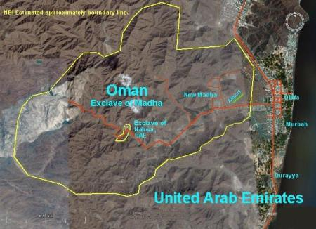
The fried egg of the desert. The United Arab Emirates is a federation whose territorial organization is a strange puzzle product of tribal struggles and disputes, and which was delimited by British surveyors in the fifties of the twentieth century. In that puzzle, Mahda and Nahwa stand out. Nahwa is a small town in Oman surrounded by Mahda, which belongs to the Arab Emirates. But Mahda in turn is completely surrounded by Oman territory. An enclave within another enclave, or a metaenclave.
TOP 15:
Lesotho
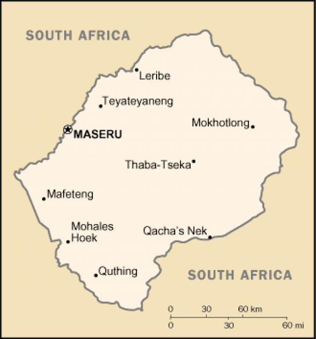
Lesotho, 1 whose official name is Kingdom of Lesotho (in sesotho: Muso or Lesotho), is a country in southern Africa, geographically and politically nestled within South Africa. He is a member of the Commonwealth of Nations (British), and was previously known as Basutoland. The vernacular name of the country, Lesotho, can be translated as "the country of which sesotho speak". Lesotho is located in South Africa, completely surrounded by South Africa and, therefore, lacks access to the sea. Its territory occupies an area of 30,355 km², which by comparison also corresponds to the Belgian or Galician surface.
TOP 14:
Martín García Island
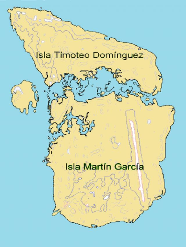
It is an island of the Río de la Plata under the sovereignty of the Argentine Republic, located 3.3 km from the tip of Martín Chico and 1.5 km from the group of Argentine alluvial islands that make up Oyarvide Island. This Argentine exclave in Uruguayan waters is part of the La Plata party in the province of Buenos Aires. Immediately north of Martín García is the Uruguayan island Timoteo Domínguez, formerly called Punta Bauzá by Argentina, which disputed its possession until 1973. The two islands joined naturally due to alluvial sedimentation, so, since the agreement of 18 In June 1988, between the two governments, a dry border has been established on the now Martín García island - Timoteo Domínguez. Other alluvial deposits created the Hercules islets off the northwest coast of Martín García, currently merged and under Uruguayan sovereignty.
TOP 13:
Büsingen am Hochrein, Germany within Switzerland.
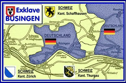
Büsingen is the only German municipality that has its own registration, and also the only one where the Swiss franc is legal tender, or where residents have the right to Swiss citizenship. The integration of this small German island in Switzerland is total, so much so that until the entry of Switzerland into the Schengen system in 2009 it belonged to the customs system of the Swiss Confederation. The town has Swiss and German postal codes and police from both countries, too. The origin of the enclave dates back to the 18th century, when, after many disputes, Austria sold all the territories around the town to the Swiss canton of Schaffhausen, expressly excluding Büsingen.
TOP 12:
Campione d'Italia, Italy within Switzerland.
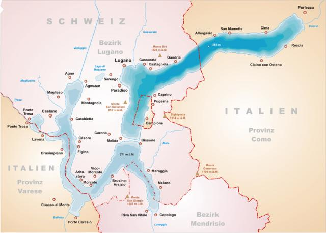
The most expensive and least-known tax haven in the world is located on the shore of Lake Lugano. Campione d'Italia, a town that owes its location to an inheritance of the eighth century (almost nothing) is a place with beautiful views, where taxes are non-existent and everything, banks, mail, phones, is Swiss , except the laws.
TOP 11:
Kaliningrad
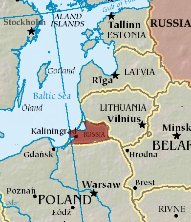
The former Prussian Königsberg, is a port city in Eastern Europe belonging to Russia and located in an exclave at the mouth of the Pregel River, which drains into Lake Vistula, in turn communicated with the Baltic Sea by the Baltiysk Strait. It is the capital of the Kaliningrad Oblast, which occupies 15 100 km² and has a population of 968 200 inhabitants (2004). This oblast (region or province) is isolated from the rest of the Russian territory, with borders to the north with Lithuania and to the south with Poland, both belonging to the European Union (EU).
TOP 10:
Kowloon, walled China inside Hong Kong
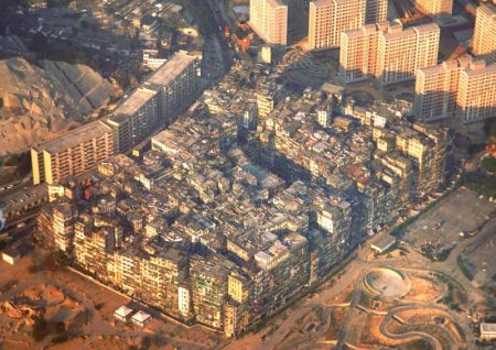
The walled city of Kowloon was a Chinese enclave within the British colony of Hong Kong, emerged from the treaty of the late twentieth century by which the British were organizing the colony. The null control that both the Chinese and British could exert over the place led to Kowloon becoming a place outside the law, of any law. In the mid-nineties, when it was dismantled, it was the human settlement with the highest population density in history.
TOP 9:
Cooch Bihar, or the recurring enclaves, India and Bangladesh
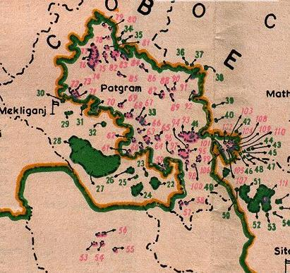
If Baarle holds the European record, the world record for border mental alienation is in the Cooch Bihar region, between India and Bangladesh. 92 Balngladesian enclaves within India (21 of them within other Indian enclaves in Bangladesh) and 102 Indian enclaves in Bangladeshi territory (three of them in other enclaves, and one of them within a metaenclave) in which seventy thousand people reside whose lives are marked dramatically by the political situation of perpetual tension between two neighbors not too well avenged.
TOP 8:
The train enclaves, Germany within Belgium.
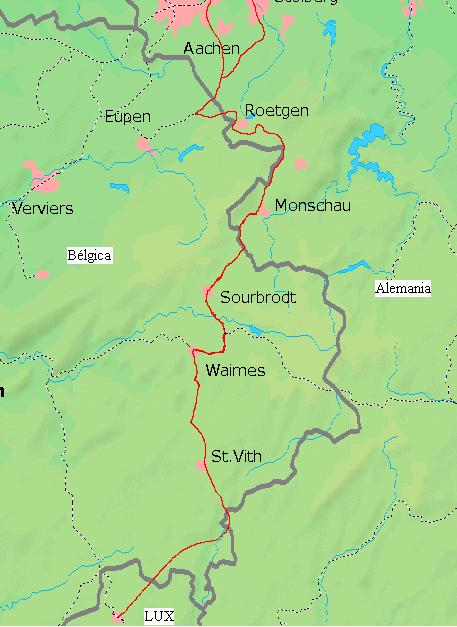
One of the rarest borders in Europe. After World War I, the Treaty of Versailles granted Belgium sovereignty over a railway line that ran through German territory and cut at various points with the new border. The situation left up to five pieces of Germany physically separated by just three meters of Belgian territory from the rest of the country. The railroad was dismantled, but the ground through which it circulated remains under Belgian sovereignty.
TOP 7:
San Andres and Providencia archipelago
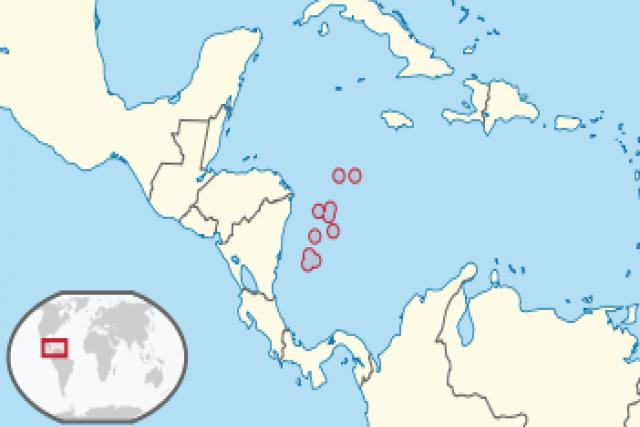
The archipelago is Colombian territory within the Nicaraguan Sea. On November 19, 2012, the International Court of Justice unanimously resolved that the Republic of Colombia has sovereignty over the archipelago after an extensive litigation initiated by Nicaragua in 2001.
TOP 6:
Republic of San Marino
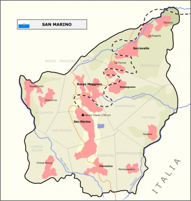
It is a constitutional republic and the oldest sovereign state in the world. It is an enclave surrounded by Italian territory, between Emilia-Romagna and Marche. It contains Monte Titano, 739 meters, and is only 10 kilometers from the Adriatic Sea, although the country has no access to the sea. It is one of the European microstates and its predominant religion is the Catholic.
TOP 5:
Baarle, Belgium within the Netherlands within Belgium, and vice versa.
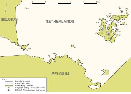
Europe's demented border record is in Baarle Hertog and Baarle Nassau (Belgium and Holland, respectively). Twenty-two Belgian enclaves in the Netherlands and eight Dutch enclaves in Belgium (seven of them within other Belgian enclaves in the Netherlands) make Baarle a place of pilgrimage for border lovers. Breweries in two countries, border killings, banks that could not be inspected and pirate radio stations in two countries, Baarle is full of stories that will drive the geek of the borders in joy.
TOP 4:
The smallest metaenclave in the world
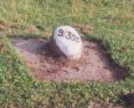
The smallest enclave in the world is also in Cooch Bahar. This is an unnamed Bangladeshi metaenclave, which has an area of only 53 m².
TOP 3:
Vatican City
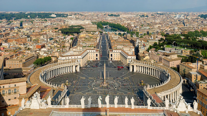
It is one of the six European microstates. The Vatican City proper has an area of 0.439 km² (44 hectares), 1 and a population of approximately 900 inhabitants, 2 making it a hybrid city elevated to the rank of independent state, being also the smallest country in the world , and the only one whose official language is Latin. It is so small that only St. Peter's Basilica is 7% of its surface; the basilica and St. Peter's Square occupy 20% of the territory, which makes it the most urbanized independent territory in the world. The Vatican City began its existence in 1929 after the signing of the Lateran Pacts between the Holy See and the then Kingdom of Italy, which in 1870 had conquered the Papal States.
TOP 2:
Suite 212 of the Claridges Hotel, Yugoslavia within the United Kingdom.
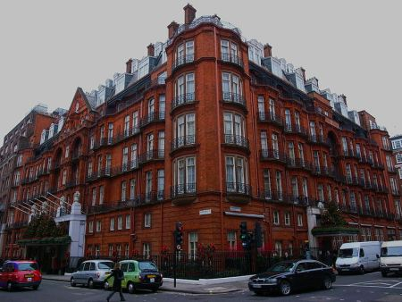
In the middle of World War II, the birth of an heir to the Yugoslav throne caused the temporary transfer, for 24 hours, of the sovereignty of a single room in a hotel from London to Yugoslavia. It is the smallest and ephemeral enclave of all time.
TOP 1:
Llivia Spain within France.
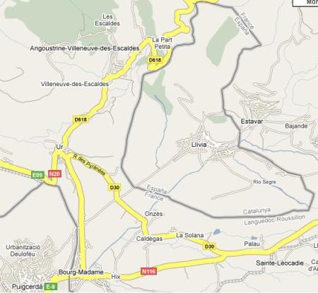
Located north of the province of Girona, Llivia is a small town of just over 1,500 inhabitants whose twelve square kilometers of surface are completely surrounded by French territory. It owes its situation to a technicality, being “villa” instead of “town”, when 33 municipalities of Cerdanya were transferred to France in 1660. The situation of the lliviencs was quite uncomfortable until the Schengen Treaty entered into force, in 1995, but it also caused funny situations, such as the War of the Stops.

